 |
| http://pcdn.500px.net/11722427/16e3a629a4c605d01a652576 bb3c161b3bcd5b16/4.jpg This is a picture of a two layer lenticular cloud over Mount Fuji. This type of cloud can be a very good sign for gliders. The world's greatest gliding records have been built on updrafts from conditions which are perfect for forming lenticular clouds. For powered aircraft, however, they signal powerful turbulence and the threat of a crash. |
 |
http://1.bp.blogspot.com/-8UpvLkP19FQ/T2jL1BIOAtI/
AAAAAAAAIW8/ebG5fwS8GCo/s1600/
isobars+causing+winds.jpg
This map shows Asia. On a global scale, areas of
high
pressure follow areas of low pressure in a never
ending cycle. Where a high pressure air mass comes
in contact
with a low pressure air mass, steep isobars
are
observed. This indicates the creation of wind
as air rushes to the
low pressure.
|
At 1:58 P.M. local time on March 5, 1966, BOAC flight 911
left Haneda Airport for Hong Kong. It was a clear day and Captain Bernard
Dobson received permission to amend the flight plan so he could fly over Mount
Fuji. The plane began climbing southwest towards Mount Fuji, reaching an
altitude of 17,000 feet. When the aircraft encountered an updraft, the
pilot reduced airspeed, allowing the air to carry them. Shortly thereafter, the
plane hit a violent downdraft. With their reduced speed, and an already low
altitude, the plane was unable to power out of the turbulence. The vertical fin
failed and the plane entered a flat spin, resulting in a crash that killed 124
people.
 |
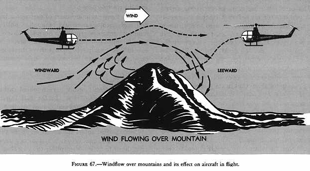
| http://www.popularmechanics.com/technology/aviation/safety/4327148 As air flowing from areas of high pressure to low pressure encounters topographic barriers, it chooses to either go around or over the barrier. Air is typically forced over Mount Fuji. Air cascades down the leeward side of the volcano, creating updrafts, downdrafts and rotors. |
 |
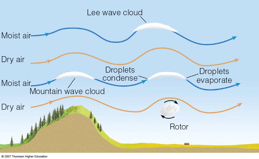
| http://apollo.lsc.vsc.edu/classes/met130/notes/chapter6/graphics/ wave_clouds_schem.jpg Lenticular clouds are formed as a constant supply of cool, moist air flows over the mountain. For clouds to form, the air parcel must reach the lifting condensation level, or dew point. |
What
Captain Dobson did not know was that a steep pressure gradient had settled over
Mount Fuji and its surrounding area due to atmospheric subsidence following a
cold front the day before. This created stable north to northwest winds over
Mount Fuji’s summit. As powerful winds flow perpendicular to orographic
topography they produce lee waves, which aviators commonly refer to as mountain
turbulence. These waves created strong updrafts and downdrafts as the air descended the leeward side of Mount Fuji
Lenticular clouds are usually the harbingers of strong
mountain turbulence and are commonly seen around Mount Fuji. However,
conditions that day were too cold and dry for air parcels to reach the dew
point and form clouds. Unaware of the hazardous conditions, Captain Dobson flew
directly into the turbulence. The wind propelled the airplane out of the sky
under an estimated 7.5 g-units of force. Later, meteorological reports concluded
that winds at the summit of Mount Fuji were upwards of 70 knots. This accident,
and many like it around the world, led to in depth meteorological research on
turbulence specific to mountainous regions.