Sunday, November 11, 2012

The Dangers of Downdraft

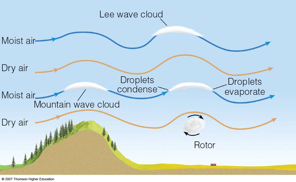
http://pcdn.500px.net/11722427/16e3a629a4c605d01a652576
bb3c161b3bcd5b16/4.jpg

This is a picture of a two layer lenticular cloud over Mount Fuji.  This type of cloud can be a very good sign for gliders.  The world's greatest gliding records have been built on updrafts from conditions  which are perfect for forming lenticular clouds. For powered aircraft, however, they signal powerful turbulence and the threat of a crash.  


http://1.bp.blogspot.com/-8UpvLkP19FQ/T2jL1BIOAtI/
AAAAAAAAIW8/ebG5fwS8GCo/s1600/
isobars+causing+winds.jpg
This map shows Asia. On a global scale, areas of high
 pressure follow areas of low pressure in a never 
ending cycle. Where a high pressure air mass comes 
in contact with a low pressure air mass, steep isobars
 are observed. This indicates the creation of wind 
as air rushes to the low pressure. 
At 1:58 P.M. local time on March 5, 1966, BOAC flight 911 left Haneda Airport for Hong Kong. It was a clear day and Captain Bernard Dobson received permission to amend the flight plan so he could fly over Mount Fuji. The plane began climbing southwest towards Mount Fuji, reaching an altitude of 17,000 feet. When the aircraft encountered an updraft, the pilot reduced airspeed, allowing the air to carry them. Shortly thereafter, the plane hit a violent downdraft. With their reduced speed, and an already low altitude, the plane was unable to power out of the turbulence. The vertical fin failed and the plane entered a flat spin, resulting in a crash that killed 124 people.

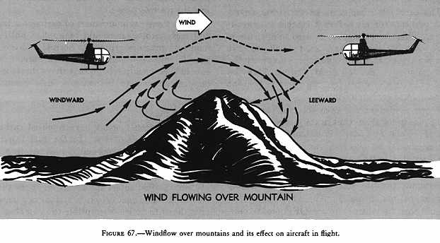
http://www.popularmechanics.com/technology/aviation/safety/4327148
As air flowing from areas of high pressure to low pressure encounters
topographic barriers, it chooses to either go around or over the barrier.
Air is typically forced over Mount Fuji. Air cascades down the leeward
 side of the volcano, creating updrafts, downdrafts and rotors.
 
http://apollo.lsc.vsc.edu/classes/met130/notes/chapter6/graphics/
wave_clouds_schem.jpg
Lenticular clouds are formed as a constant supply of cool, moist
air flows over the mountain. For clouds to form,
the air parcel must reach the lifting condensation
level, or dew point.
  
What Captain Dobson did not know was that a steep pressure gradient had settled over Mount Fuji and its surrounding area due to atmospheric subsidence following a cold front the day before. This created stable north to northwest winds over Mount Fuji’s summit. As powerful winds flow perpendicular to orographic topography they produce lee waves, which aviators commonly refer to as mountain turbulence. These waves created strong updrafts and downdrafts as the air descended the leeward side of Mount Fuji

Lenticular clouds are usually the harbingers of strong mountain turbulence and are commonly seen around Mount Fuji. However, conditions that day were too cold and dry for air parcels to reach the dew point and form clouds. Unaware of the hazardous conditions, Captain Dobson flew directly into the turbulence. The wind propelled the airplane out of the sky under an estimated 7.5 g-units of force. Later, meteorological reports concluded that winds at the summit of Mount Fuji were upwards of 70 knots. This accident, and many like it around the world, led to in depth meteorological  research on turbulence specific to mountainous regions.


http://www.flightglobal.com/FlightPDFArchive/1967/1967%20-%201067.PDF


Wednesday, October 10, 2012

The Secret Life of Water


Mount Fuji is divided by both time and composition. The ancient mountain, Kofuji, is composed primarily of impermeable mudflows. The modern volcano, Shinfuji, resulted from layers of basaltic lava flows and volcanic ash. Due to its basaltic nature, the porous rock of Mount Fuji is an excellent aquifer.
Komitake and Ashitaka preceded Mount Fuji and through time became part of Fuji's base. Kofuji is primarily composed of tephra, versus Shinfuji which developed from massive lava flows.
 
This image depicts how Shinfuji developed around Kofuji. Shinfuji most likely began as a rhyolite dome in Kofuji's crater, which grew through the build up of lava flows. The lava flows laid down layers of basalt, which has a high porosity. This allows surface runoff to seep into joints and fissures to create aquifers.
 
When precipitation falls on Mount Fuji, the runoff flows into the joints and fissures of the Shinfuji deposits until it meets the hydrologic barrier of the Kofuji mudflow layer. The water slowly filters through the volcanic rock. The clean water then seeps from the rock to form springs such as Wakutama Pond, Kakita River Spring, and Kohama Pond. Water cascades from a gap between lava layers, creating Shiraito Falls. Shiraito Falls feeds the flow of Shiba River, acting as baseflow to a stream.
 
The hydrologic cycle illustrates the movement of water through earth's system. It is estimated that 2.2 billion tons of rain and snow fall on Mount Fuji every year. After evaporation, about 4.5 million tons of groundwater are stored each day. The precipitation percolates through the volcanic rock and enters the aquifer. When the aquifer is full, the water spills out through landforms such as springs. It then flows into lakes and rivers, and eventually out to the ocean.
 
This photo distinctly shows the water of Shiraito Falls flowing from between rock layers. Shiraito Falls is the baseflow for the Shiba River, which is a tributary of the Arakawa River.
 
When Shinfuji formed, lava flows blocked drainage pathways and trapped water, eventually creating five lakes. Now, exposed lava tubes act as pipes directing runoff into the lakes and other hydrologic features of Mount Fuji. In 864 AD, the Aokigahara lava flow split Lake Senoumi into lakes Motosu and Sai and crept into Lake Shoji. These three bodies of water share the same source and therefore cycle at the same rate due to the movement of groundwater through the lava.
 
This picture characterizes the age and paths of various lava flows. The lava flow which split Lake Senoumi is relatively new. This process illustrates the ease with which lava cuts off drainage pathways. It should be noted that the same lava flow leads directly to lakes Motosu, Shoji, and Sai, adding evidence that the three lakes share a water source.
 
The lakes are directly in line with the lava flows, suggesting that the water which flows through the closest lava flow feeds the lake. This map shows the relation of the lakes to Mount Fuji.
Mount Fuji has three main aquifers: the superficial, the New Fuji Lava, and the Old Fuji aquifers. Vertical movement of groundwater mixes the pure water of the Old Fuji aquifer with newly recharged and polluted water from the New Fuji Lava and superficial aquifers. Anthropogenic wells in the area allow salt water from Suruga Bay to penetrate the groundwater, leading to further contamination. This water is used for agriculture, industry and recreational activities. Increasing pollution at all groundwater levels may lead to the water being unsuitable for human consumption.
 

https://www.jstage.jst.go.jp/article/hrl/5/0/5_0_58/_pdf


What is shown in this illustration: 1) The superficial aquifer occurring either in the alluvial deposits (close to the lowland) or in the surface volcanic ash beds (on the slope area), 2) The aquifer residing in the older lava flow of the New Fuji Lava Aquifer and 3) The Old Fuji Aquifer residing in the pyroclastic mudflow deposits of the Old Fuji Aquifer. "Tsuchi (2007) stated that during the solidification of basaltic lavas, the surface and the bottom of the lava flow are cooled rapidly, and crushed (https://www.jstage.jst.go.jp/article/hrl/5/0/5_0_58/_pdf)." These crushed and permeable parts are called clinkers, which allow groundwater to flow through lava. Due to the permeabilty of the clinkers,and the proclivity of basalt to fracture and fissure, paths form through the rock which separates the aquifers. This leads to vertical movement of groundwater through the rock layers and explains how pollution enters the older aquifer, contaminating what should be pure.


http://www.jnto.go.jp/eng/indepth/scenic/mtfuji/fuji_02.html
Suruga Bay is surprisingly close to Mount Fuji. With such proximity, it is easy to understand how anthropogenic wells could contaminate the Mount Fuji aquifer with salt water.


http://www.asianartmall.com/mtfujiarticle.htm
 

Wednesday, September 19, 2012

The Meeting Place of Chaos


The Japanese island of Honshu is the meeting place of four tectonic plates: the Pacific Plate, the Okhotsk Plate, the Amur Plate and the Philippine Plate. The Okhotsk Plate was once part of the North American Plate, but is now an independent plate. Similarly, there is debate as to whether the Amur Plate is independent or whether it is still part of the Eurasian Plate. The Amur and Okinawa Plates are subducting the Philippine Plate. The Philippine and Okhotsk Plates are subducting the Pacific Plate.
 

Through time, these plates have given rise to the landforms of Japan. One of these is the composite volcano Mt. Fuji.


Mt. Fuji is located about twenty-three miles from the plate convergence zone. Composite volcanoes are common at subduction zones, as evidenced by the volcanoes of the Ring of Fire.


When an ocean plate is subducted by a continental plate, magma can rise as dewatering occurs. Dewatering is the release of water from hydrated minerals. Dewatering happens at specific temperatures and pressures for different minerals.


The released water lowers the melting point of the mantle rock. The mantle rock partially melts and becomes less dense than the surrounding rock. As it rises, it pools temporarily in the lower region of the continental lithosphere. The magma then rises through the crust and gathers crustal silica rock. Then it pools in the magma chamber of a volcano. Pressure and gases build up until the volcano erupts, spewing lava and pyroclastic flows over the landscape with explosive force. This is how Mt. Fuji and the surrounding area came to be volcanic.

Sources

Friday, August 24, 2012

Introduction


Greetings!

My name is Caitlin Reusch and I just transferred to CU Denver. I am in between my junior and senior years of college. My major is geography, so there is no need to convert me to the major. I have been an Art major, a Biology major, and a Microbiology major. I love to travel; I have been to Europe several times and Japan twice. I have lived a summer in England, danced in the Scottish rain, crossed into Italy from Germany through the Alps, and been lost in La Samaritan department store in Paris. For someone of twenty years old, I have been lucky in my travel opportunities. I hope it remains so, and that I continue to have adventures until I am so old I can no longer walk.

I have chosen Mt. Fuji and its surrounding area because I have a great love for foreign places, especially Japan. It is a region I do not know much about and I am eager to learn more. I am particularly interested in the Aokigahara Forest, which is well known as a suicide destination in Japan. It has been popularized by Japanese media, and subsequently romanticized by the Japanese population. Couples go there to die together in the eerily silent forest. It is both a creepy and fascinating location.

 I hope to discover more about the Mt. Fuji area and Aokigahara in particular, such as why it is such a popular place to go. I will explore the landscape of the area. In doing so, I hope to find out why it is so popular. What draws people to this peaceful, but deadly, place? What landforms or functions of geography make this place so peaceful and silent? These are a few of the question I hope to answer for myself.